Thursday, September 29, 2005

The calm before the storm: real calm?

Dear people,

Now that the marks are back, it is time for all of us to finally realise the implications of all we have done in term 3 and in these 3 years.

Have you done enough? Have you followed your study plan? How much more is left?
Does 'covering' each topic guarantee your ability to answer a question related to it? DOES IT?

For some of you, I think you know full well, though I suspect there are others who are still trapped in that fantasy that there is enough time for you to take it easy.

------------
Its time to maximise your chances! Talk to your seniors who have made it and ask them how they did it.


Mr Toh
------------------
Teacher: What is the axis of the earth?

Student: The axis of the earth is an imaginary line which passes from one pole to the other, and on which the earth revolves.

Teacher: Very good. Now, could you hang clothes on that line?

Student: Yes, Sir.

Teacher: Indeed, and what sort of clothes?

Student: Imaginary clothes, Sir.
-------------------

Friday, September 09, 2005

The eleventh hour is upon us

I can already feel, very concretely, the panic growing and the frenzy rising.

I get an average of 7 smses per day with questions on Physical geog.
I should be happy with your diligence, though I wonder if this level of awareness shouldnt have started a year ago. :P

I realise I might have neglected answering some of your smses simply because you messaged me while I was at course or eating or whatelse and I didnt reply you immediately. I might have also forgotten to answer and deleted the message.

My apologies.

Can I ask who requires me to stay back on monday evening for night study to consult about the paper?

In the meantime, pls have a look at the syllabus document and get a feel of what the entire subject is about.
If you are reading this doubtless you have internet access. Do your research beyond the notes WHILE CONSULTING THE SYLLABUS DOCUMENT cos some information might be presented which are not that crucial in the syllabus. Research CAREFULLY.

All the Best!

Sunday, September 04, 2005

Email Address and island chains

Hi people,

I would be glad to receive your email addresses (especially those with blogger accounts) so that I can invite you to be co-owners of the page (so that you can create new posts instead of just responding to old ones).

---------------

re the question "using diagrams, explain how island chains can result from 'hot spot' activities" from (whoever you are :P pleease tell us your name lah)

What are the key terms to be defined?
1) island chains
chains of islands formed as a result of volcanoes emerging through the crustal plate from a hot spot plume, and then becoming extinct as the plate moves relatively from the plume (which has a fixed location), such that new areas of the plate (adjacent to the earlier volcano) lie over the plume and are eventually penetrated by hot rising magma to form new volcanoes.

This progression results in a chain of volcanic islands. Examples of island chain in the Pacific plate:
Kauai (oldest), Oahu, Maui, Hawaii(youngest)

2) hot spot activities
Relatively small, long-lasting, and exceptionally hot regions -- called hotspots -- that existed below the plates provide localized sources of high heat energy (thermal plumes) to sustain volcanism.
Specifically, Wilson hypothesized that the distinctive linear shape of the Hawaiian Island-Emperor Seamounts chain resulted from the Pacific Plate moving over a deep, stationary hotspot in the mantle, located beneath the present-day position of the Island of Hawaii.
-Heat from this hotspot produced a persistent source of magma by partly melting the overriding Pacific Plate.
-The magma, which is lighter than the surrounding solid rock, then rises through the mantle and crust to erupt onto the seafloor, forming an active seamount.
-Over time, countless eruptions cause the seamount to grow until it finally emerges above sea level to form an island volcano.
(source: http://pubs.usgs.gov/publications/text/hotspots.html)


Some references for you to practice your drawings of island chains related to hotspots:
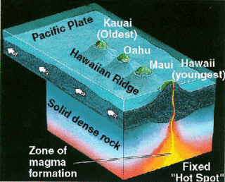
http://volcano.und.nodak.edu/vwdocs/vwlessons/hot_spot_pics/Matt's_Island_Diagram.gif